Tuesday, May 21st
 The morning brought oatmeal and warm weather. I slept
atop my sleeping bag again, making me
feel silly for packing this heavy thing. Today's goal was Davenport Gap,
back at Mountain Moma's,
21 miles south. It was sure to be a long day, but I was told that the
terrain was not difficult.
The morning brought oatmeal and warm weather. I slept
atop my sleeping bag again, making me
feel silly for packing this heavy thing. Today's goal was Davenport Gap,
back at Mountain Moma's,
21 miles south. It was sure to be a long day, but I was told that the
terrain was not difficult.
The first few hours were not difficult, and I followed a winding path around
small hills and into moist
valleys, often hiking along streams and intersecting with old abandoned
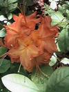
roads. The plant life was
all very green and beautiful, along with a new colour -- orange! The flame
azeleas had begun to
bloom. They're orange and yellow-streaked, and look like a tree afire when
the sun shines through
them. It was a nice change of colour.
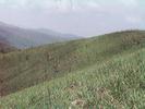 I soon popped out of the woods to Max Patch. Max
Patch is a huge bald, looking like a British
excuse for a mountain, a big grassy tor with a dirt path carved up the side.
It looked like it would
take but a minute to cross, but it took considerably longer. I suppose
that, being bald, (Max Patch,
not me) I lacked points of reference. I stopped halfway up, pushed to the
west by the stiff wind,
and climbed a few feet down the hill to get out of the breeze. I took the
opportunity to munch on a
Snickers and eat a few spoonsful (Is that a word? Maybe its
spoonfuls...that doesn't look right.
Passerbys / passersby? Cope.) of peanut butter. I've been pondering just
eating raw oatmeal,
some hot water, a little granola and some raisins, one at a time. It all
goes to the same place.
I soon popped out of the woods to Max Patch. Max
Patch is a huge bald, looking like a British
excuse for a mountain, a big grassy tor with a dirt path carved up the side.
It looked like it would
take but a minute to cross, but it took considerably longer. I suppose
that, being bald, (Max Patch,
not me) I lacked points of reference. I stopped halfway up, pushed to the
west by the stiff wind,
and climbed a few feet down the hill to get out of the breeze. I took the
opportunity to munch on a
Snickers and eat a few spoonsful (Is that a word? Maybe its
spoonfuls...that doesn't look right.
Passerbys / passersby? Cope.) of peanut butter. I've been pondering just
eating raw oatmeal,
some hot water, a little granola and some raisins, one at a time. It all
goes to the same place.
I shouldered my pack and headed off of Max Patch, winding back and forth on
the summit, finally
reaching the woods and getting out of the breeze. I was halfway to the
shelter when I crossed
paths with High Tech, who had started at Mountain Moma's the day before. I
think "crossed paths"
would be the wrong phrase. He was snoozing in his bivy sack, sleeping smack
dab in the middle
of the trail. That seemed like a good idea, something I'll have to try. I
sat down by him and noisly
made some vegetarian chili as part of the day's long, spread-out lunch.
I'll use this opportunity to relate something that High Tech told me of some
time ago, of his only
bear encounter so far. He was walking through the Smokies, I'm not sure
where, hiking alone for
the day, when he came across something in the dirt. Something was scrawled,
as if with a hiking
staff, but he wasn't sure what. After a few minutes of studying it and
tracing it, he realised that it
said "BEAR". Above it was an arrow, pointing ahead and to the right a bit.
Following the arrow, he
looked up and into the woods. There, just a few yards away, was a bear.
High Tech made like a
tree and got out of there. The trail sure is an odd place.
Anyhow, I packed up and left High Tech to his own devices, passing a few
more hikers headed
north. I got to Groundhog Creek Shelter in mid-afternoon, encountering Zen
Pig (Harry Siegel), a
fellow whose entries I had read in a number of registers, and several other
thru-hikers. I was
desperate for water by then, so I hopped and danced, barefoot, down the side
trail to the stream
and pumped water directly into my mouth. I'd love to be able to use this
space to describe what it
tasted like. But how, really, does one describe the taste of water? I
could say what memories it
piques, what it reminds me of, but I just don't know how to describe it.
Despite, I sure did like that
water.
I moved on, anxious to get to Interstate 40 before dark and hitch back to
Hot Springs. The
remaining miles were actually fairly unexciting. That's not to say that I
didn't enjoy them. They just
didn't lend themselves to an outstanding description. Just the same ol' beauty!
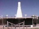 I came across a VOR,
an airplane guidance system that hummed loudly atop Snowbird Mountain. I
could hear it as I
approached. It was actually entirely unexciting to look at it, but neat to
see. Poetry inspired:
Ode to a VOR
oh
humming VOR
how I wish you'd hum for me
hum
hum
VOR
hum
Give me my black turtleneck and an NEA grant!
The rest of the hike was nice. The trail went down, down, down into the
valley carved by the French
Broad River (Quite a name, eh? There's a rule for life -- Never cross a
French Broad.) and
construction workers who put in Interstate 40. The trail goes right under
the Interstate. I dropped
my pack and slackpacked to as far north as I'd come last week, turned
around, and came straight
back. I noticed, after having done it, that I'd noticed very little of what
I'd liked. Not because of my
lack of a pack, just because I was in a hurry to get to Hot Springs.
There's something to avoid in
the future.
I spent over two hours trying to get a ride. People waved, truckers honked,
but most everybody
zipped past at 70 MPH, oblivious to me. It finally got fairly dark out, and
I got fairly pissed off, and
so we went our seperate ways. I headed south, hoping to camp up the
mountain a bit. I stomped
down the trail, stumbling in the dark, cursing all those who didn't pick me
up. I came to a fairly flat
spot after half a mile or so. I cleared an area in the leaves as it began
to rain. I set up my tent in
the heat and humidity, getting wet from the splashes of rain, tossed my pack
in and dived in after it.
My tent was like a sauna, sweat dripped down my face. I tried to cook in my
tent, as it was raining
outside quite hard, and it only got hotter. I ended up sitting naked in
front of my WhisperLite
eating undercooked macaroni and sweating profusely, angry that I wasn't in a
motel room in Hot
Springs.
After an hour or so I managed to toss and turn my way to sleep, lying on my
useless sleeping bag
and cooling myself with a wet bandana.
Miles Today: 20.5
Today's Song: Ernie, "Rubber Ducky"
Next Entry